| "In finding economic solutions to environmental problems, we are discovering ways in which the goal of regulation, rather than the process, is paramount".
William H. Schlesinger
Dean, Nicholas School of Environment and Earth Sciences
Duke University
|
Definition of Water Quality Problem: American Rivers.org lists the Peace River as the 8th most endangered river in the U.S. as a combined result of sprawl, agriculture, and phosphate mining in the central Florida region. According to the Southwest Florida Water Management District (SWFWMD), water quality in the upper Peace River is especially poor from high nutrient loading into watersheds (phosphorus and nitrogen).
Of special concern is Lake Hancock, the largest water body flowing into the Peace River. With excessive nutrient loading into the lake, very high levels of blue green algae form which results in a depletion of oxygen in the water. Also, recent research by the University of Miami suggests that high levels of nitrogen and phosphorus in the Peace River may be increasing outbreaks of Red Tide in Florida's coastal waters.
Plantations using fast growing trees such as Eucalyptus grandis and cottonwoods can act as beneficial "phosphorus sinks" -- capturing sizable levels of phosphorus primarily in the trees' leaves. When the trees are harvested, captured phosphorus is then removed from the site.
| Integrating managed forestry (e.g., energy crop tree farms) and grass uplands into wetland areas can be an important and cost effective tool in improving regional water quality.
|

Science Background: Soil science research has clearly established that phosphate mining clay settling area (CSA) soils are high in phosphorus (P), potassium (K), magnesium (Mg), and calcium (Ca). While mining alone is not "the" cause of high phosphorus levels in Peace River watersheds, a few points are believed relevant:
Soil science has established that increased amounts of
 phosphate in soils result in increased levels of phosphate in phosphate in soils result in increased levels of phosphate in
 soil solutions [1].
Soils on CSAs are highly compacted and become saturated soil solutions [1].
Soils on CSAs are highly compacted and become saturated
 in Florida's rainy season resulting in "milky white" in Florida's rainy season resulting in "milky white"
 stormwater runoff in summer months.
According to University of Florida research, sediment and stormwater runoff in summer months.
According to University of Florida research, sediment and
 total phosphorus contained in CSA stormwater water runoff total phosphorus contained in CSA stormwater water runoff
 can be a water quality concern [2].
In a 1992 U.S. Geological Survey Study, creeks on can be a water quality concern [2].
In a 1992 U.S. Geological Survey Study, creeks on
 reclaimed mine sites were found to carry more than 3 to 6 reclaimed mine sites were found to carry more than 3 to 6
 times the amount of dissolved solids than creeks in unmined times the amount of dissolved solids than creeks in unmined
 areas. areas.
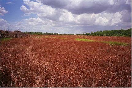
Research Approach: Even though CSAs contain high levels of P, this is not necessarily reflective of available P for flora. When soil pH levels exceed ~7.3, insoluble compounds of phosphate are created which are generally not available to plants [3]. Prior to tree planting at our CSA site (when it was a prairie of cogongrass), numerous field soil tests showed pH levels between 7.8 and 8.3 -- which is consistent with prior research findings on CSAs. Thus, in order to maximize the ability of plants and trees to uptake P on CSAs, soil pH must be lowered to more neutral levels. Also, native flora in central Florida evolved in slightly acidic soils and can not usually establish in highly compacted and alkaline clays.
Agriculture science is clear that an effective method of lowering soil pH is by adding organic matter (OM) into soils -- which initiates a soil chemistry effect of increasing humic and organic acids that combine with cations (pronounced CAT-eye-uns). We have addressed this issue by:
Below ground carbon sequestration of fast growing trees.
Mulch matting at a depth of ~3 feet.

Picture of our CSA Site before treeplanting, which was a prairie of cogongrass (herbicided in picture).

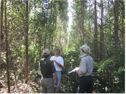
Picture of the same area, 2 and one-half years after treeplanting (trees in picture are Eucalyptus grandis).

Picture of mulch matting on our CSA site, which smothered ~ 5 bart tall stands of cogongrass.
Current tree yield estimates for Eucalyptus grandis at our treefarm are between 10 and 16 dry tons per acre per year. These tree yield estimates are consistent with findings by the U.S. Department of Energy of 90 to 100 m3 per hectare per year for eucalyptus [4]. In research perform by the University of Florida, approximately 63% of the above ground mass of trees is also contained below ground in the tree's root systems. Thus, using a yield estimate of 10 dry tons per acre per year, approximately 3 tons of carbon per acre is being introduced into soils each year [5].
Percent of Below Ground
Tree Mass (e.g., Root Systems)
to Above Ground Tree Mass.

| Key Research Finding: In both University of Florida and Oak Ridge National Lab soil research at our CSA site, soil pH has been significantly lowered to a range of 6.8 to 7.6 over a period of ~4 years.
|
Based on soil science literature, this decrease in soil pH has increased available phosphorus to trees and the now ~40 species of native flora (e.g., southern shield ferns, creeping dayflower, etc.) that have established in the forest understory.
In a paper published in The Ecological Society of America, eucalyptus trees plantations can perform as tremendous "phosphorus sinks" due to the linear correlation between (1) available soil phosphorus and (2) phosphorus contained in leaves [6]. In addition, high calcium and magnesium levels present in CSAs soils may contribute to increased phosphorus uptake by trees [7].
The 3 Zone Water Quality "Buffer Strip":
Buffer zones help prevent nutrients, especially phosphorus, from entering surface waters by trapping of sediment. Phosphorus is normally attached to the soil particles and can be absorbed by the roots of the buffer zone vegetation along with dissolved nitrogen in overland and subsurface flow.
Studies of grass filter strips have shown that trapping efficiencies of sediments only exceed 50% when there is shallow (sheet) flow rather than channeled flow (Dillaha et al. 1989) [8] . A combination of grass filter strips with woody buffer zones may be more useful, because forested uplands and wetlands have the potential to absorb and trap more sediment than grass filter strips alone [9].
A three stage strip with mature trees immediately adjacent to a water body, then a woody managed strip of trees and shrubs, and finally leaf and stem grasses farthest from the water body is the current preferred strip design [10]. The managed portion of the buffer strips is critical because it affords a means of exporting the nutrients out of the buffer strip in the harvested woody tissue. The young developing trees in the managed strip also take up more nutrients at that life stage than mature trees.
The 3 Zone "Buffer Strip" Concept
Aerial View Schematic:

Ground View Schematic: 

| Zone 1 (wetlands) -- consists of undisturbed forest and contains mostly mature trees which stabilize the water's edge and provide shade to maintain generally beneficial lower water temperatures. There is nutrient uptake occurring in this zone, but not to the extent of Zone 2. |
| Zone 2 (forested uplands) -- consists of vigorously growing trees and shrubs which are periodically cut as they approach maturity. This is the zone of maximum nutrient uptake because younger trees require more nutrients for growth than mature trees. |
| Zone 3 (grass, legume, shrub uplands) -- consists of a filter strip where concentrated channel flows from adjacent lands are converted to dispersed sheet water flows. This filter strip may be periodically harvested or grazed upon (e.g., growing legumes like alfalfa) to facilitate maximum nutrient uptake and removal [11].
|
Water Quality Improvement: As we continue to demonstrate in a "real world" setting, biomass energy crops can have significant value added economic and environmental benefits beyond traditional energy issues. If Government, Industry, Agriculture, and Environmental Interests work together, tremendous accomplishments can be achieved to protect our air, land, and water resources in a cost effective way. In using an approach that includes market based incentives, often the environmental results can far exceed that of governmental command and control regulations alone.
Value Chain of Growing Energy Crops on Mined Land:

| Water Quality Strategy: To Form partnerships between Governmental Regulators/Agencies and Farmers to utilize phosphate mining clay settling area (CSA) marginal lands as water quality filtration zones.
|
The key component of the above strategy is to combine regulatory and market based incentives to achieve environmental goals. By incorporating farming into environmental regulations, profits from cash crops could help pay for the costs of restoring/reclaiming damaged marginal lands (e.g., building soil organic matter, eliminating invasive weeds like cogongrass, etc.). For example:
Under Florida Department of Environmental Protection's
 (FDEP) Phosphate Mining Regulations and USDA (FDEP) Phosphate Mining Regulations and USDA
 Programs, Farmers are compensated for the cost of Programs, Farmers are compensated for the cost of
 herbiciding and field burning of invasive weeds.
However, the cost of mulch matting (which kills cogongrass herbiciding and field burning of invasive weeds.
However, the cost of mulch matting (which kills cogongrass
 AND builds soil OM) is not currently compensated.
If "Best Management Farming Practices" could be AND builds soil OM) is not currently compensated.
If "Best Management Farming Practices" could be
 developed between Governmental Agencies and Farmers developed between Governmental Agencies and Farmers
 as to what type of crops could be grown and their as to what type of crops could be grown and their
 management, the profit from cash crops could help pay for management, the profit from cash crops could help pay for
 reclamation and/or restoration.
In addition to cash crops, other market based incentives reclamation and/or restoration.
In addition to cash crops, other market based incentives
 could be created for Farmers (e.g., selling carbon could be created for Farmers (e.g., selling carbon
 sequestration credits, quality wetland creation credits, water sequestration credits, quality wetland creation credits, water
 quality credits, increased land value) quality credits, increased land value)
(1) Busman, L., Lamb, J, Gyles, R, Rehm, G, Schmitt, M. 2002. The Nature of Phosphorus in Soils, University of Minnesota.
(2) Stricker, J.A. 1991. Agricultural Use of Reclaimed Phosphate Waste Clays, in Proc. 41st annual meeting of the fertilizer industry round table, Tampa, FL Oct. 21-23. The Fertilizer Industry Round Table, Washington, DC. pp. 98-104.
(3) Busman et. al.
(4) Reis, M. G. F., and G. G. Reis. 1993. A contribuição da pesquisa florestal para a redução de impactos ambientais do eucalipto. pp. 119-35. In Anais do I Simpósio Brasileiro de Pesquisa Florestal. Society for Forest Research.
(5) 10 dry tons per acre per year times 63% times 50% (the percentange of carbon contained in trees).
(6) McColl, J.G. May, 1969. Soil-Plant Relationships in a Eucalyptus Forest on the South Coast of New South Wales. Ecology, Vol. 50, No. 3, pp. 354-362
(7) McColl, J.G. May, 1969. Soil-Plant Relationships in a Eucalyptus Forest on the South Coast of New South Wales. Ecology, Vol. 50, No. 3, pp. 359-360.
(8) Dillaha, T.A., R.B. Reneau, S. Mostaghimi, and D. Lee. 1989. Vegetative filter strips for agriculture nonpoint source pollution control. Transactions of the Samerican Society of Agricultural Engineers 32:513-519.
(9) Cooper, J.R., J.W. Gilliam, R.B. Daniels and W.P. Robarge. 1987. Riparian areas as filters for agricultural sediment. Soil Science Society of America Journal 51:416-420.
(10) Jan Ducnuigeen, Karl Williard, R.C. Steiner. 1997. Relative Nutrient Reguirements of Plants Suitable for Riparian Vegetated Budder Strips. Virgina Department of Environmental Quality, ICPRB Report Number 97-4.
(11) Welsch, D.J. 1991. Riparian Forest Buffers: Function and Design for Protection and Enhancement of Water Resources. USDA Forest Service, Northeastern Area S&PF, Forest Resources Management, Radnor, PA. 20p.
|


